
Saturday, December 29, 2012


Tuesday, December 18, 2012


Monday, December 17, 2012
Mossel Bay to Cape Town
Ahead of us lay the last leg of our 900 mile journey to Cape Town. This leg is 240 miles around the bottom of Africa making it two nights at sea. It is difficult to get a perfect weather window as the Cape Agulhas area and Cape point area often have different weather.
Our last day in Mossel Bay we visited the big museum and saw a replica of Bartholemew Diaz's ship that he sailed to South Africa in 1488. Later that night had a nice dinner in the yacht club with the Mojombo family. Very good prices here.
The weather looked good to leave the next morning and as long as we did not leave too early it looked like we would arrive at Cape Point (Cape of Good Hope) just after a big blow.
We left our anchorage at 8am and after a short bash around Cape Blaize, we motored off and on, all day with a light SE wind behind us. That evening the wind picked up to about 15 to 18 knots making a pleasant sail all night. Had only one ship to avoid as we were inside the main shipping lane. There is a lot of ships going around the bottom of Africa.
We rounded Cape Agulhas at about 7:30 am with SE 18 still blowing and the seas not too bad. Great, that's our first hurdle over with and no drama's. Using our dongle, we even managed to get some internet 6 miles from shore as we passed the Cape, so got a detailed weather update. The Cape is the Southern most point of Africa and is where the Indian ocean ends and The Atlantic starts. 25 miles past Cape Agulhas we noticed the water temp getting colder going from 67 deg f down to 58 deg f by the time we rounded Cape Point. There is a tremendous amount of sea life in this area as the shallow Agulhas bank goes out over 60 miles. We saw more bird species than we ever had at sea and also lots of fur seals and dolphins.
During the night as we started to cross the entrance to False Bay the wind began to pickup and soon it was blowing 30 knots, but at least the seas were not too bad. The weather forecast said 20 to 27 knots and easing by midnight. By two in the morning we had passed around Cape Point and the wind had eased to about 24 to 28 knots, but the seas were rougher now making for a uncomfortable ride. But soon conditions eased and by dawn the wind was way down and 2 hours later we were motoring in a dead calm, with 25 miles to go to Cape Town. For the past two weeks we had been watching the weather in this area and noticed it is almost always blowing hard here so we consider we had a comparatively easy rounding of the two Great Capes. One boat we knew got over 50 knots rounding Cape Agulhas with huge ugly seas and every 10 wave filling his cockpit. Another boat rounded Cape Point in 40 to 50 knots winds but being a large boat did fine. I think if you watch the weather carefully you can miss the big blows.
As we approached Cape Town the water was dead calm, not a cloud in the sky and we had a fantastic view of the fabled Table Mountain. The cabin floor was cold to stand on and the air in the shade of the main sail was cooler than any we had felt in a long time. As we rounded Cape Point we had stayed inside the cabin mostly, as it was freezing cold outside during the night. We watched the radar and AIS for boat traffic and only occasionally stuck our heads outside for a look at things. The wind vane did all the steering.
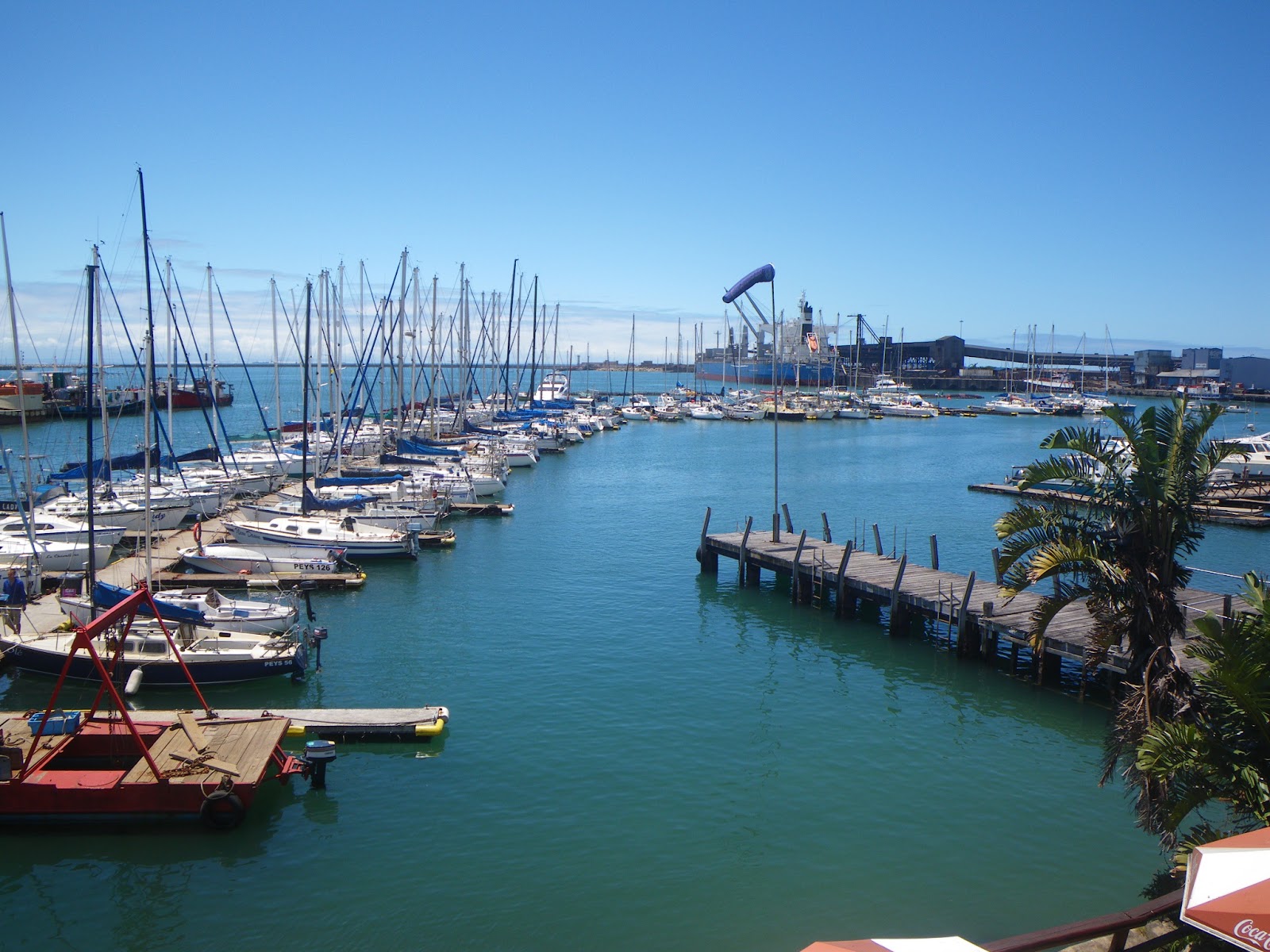
As we neared the harbour entrance we saw lots of sailboats coming out and realized they were getting ready for a race. We motored into the big harbour and headed for the marina. It is a Sunday and the marina office is closed. We had a reservation but did not know the slip number and Ian the manager had told us over the phone to go to their fuel dock if we arrived on Sunday so that's where we spend our first night in Capetown.
We visited the yacht club for a temporary membership card and had a nice shower. Monday, today is a public holiday and we noticed again all the race boats going out for the third day of the large Croc Regata. Ian gave us a slip number and we headed for our dock slip.
We could see a cloud forming on the top of table mountain, often called the table cloth. It pours over the mountain like a waterfall and disappears. From past reading we knew this was the start of a gale coming. Sure enough as we motored around the large marina we saw a bunch of race boats come charging back into the marina, the race had been canceled and it was soon blowing over 40 knots out there. We had to dodge one race boat to get into our slip and just in time. As we tied our dock lines the wind started to howl making it hard to get the lines correct. A few more minutes and we would have been stuck on the fuel dock for the day.
After making sure the boat was well tied with our heavy dock lines we did a 50 minute walk along the waterfront main road to the V and A Waterfront. There is a huge amount of shops grocery stores and other tourist activities there. It is very hot once you are out of the marina and in the sun. When we arrived back at the boat, the wind was still howling, we noticed little wind down near the waterfront mall.
INFO
-Left Mossel Bay Dec 14 2012
- Leaving Mossel bay we plotted a coarse that took us just inside the shipping lane around Cape Agulhas and then to a waypoint that took us between 6 mile bank and 12 mile banks marked on charts, putting us about 7 miles offshore. We had reasonably good seas along this route in 18 knots of wind and a 1 knot positive current between the banks. We have heard that it is not good to go around Cape Agulhas in real strong winds but Cape Point is okay in strong winds. We again used the Samm net and Peri Peri for weather when at sea.
- If you round Cape Agulhas okay but there is a SE gale pending at Cape Point you can apparently anchor in Pringle bay at 34 20.5 S 18 49.4E. I have not been there but the South African Pilot says it is the best anchorage in False Bay and good spot to sit out a SE gale and it is not much out of the way being on the outside edge of False Bay. This was our backup plan if Cape Point was going to be too wild. There is also anchoring behind some off the headlands for Westerly blows.
-There is a yellow emergency buoy just outside the entrance to the RCYC marina where we stayed. We used it for 20 minutes while I paddled my kayak in to check out if room on fuel dock. Everything was closed on Sunday.
- Waypoint of fuel dock we tied to is 33 55.216S 18 26.532E
-We are being charged 160 Rand a day for our 36ft boat, I believe this is about $5.00 a day more than Simon's Town.


Tuesday, December 11, 2012
Port Elizabeth to Mossel Bay South Africa
Port Elizabeth is a nice place to stay for a few days, but we now had a good weather wind and it was time to go. The weather window looked good for the next 5 days and we thought great, an easy trip to Cape town. Ya right! This is the bottom of Africa here and we have the two great capes to round. Cape Agulhas and then 100 miles further is the Cape of Good Hope often called the cape of storms. There almost always seems to be some sort of gale blowing here.
We motored out the port at 5:30am and about 11am the wind filled in and we had some good sailing. The seas were the most comfortable we have had in a long time. The wind got light during the night and we soon were motoring again. It was an easy night with most of the ships South of our course line and the seas pleasant. Had a few light rain showers and the wind was up and down. Around noon we listened the the local South African weather service on the VHF and big surprise! There was now a gale warning for the Cape Agulhas area and Cape Point (Cape of Good Hope). We had been talking to the Samm net for weather this morning and they mentioned nothing about strong winds coming. Cape Agulhas apparently is not a great place to be in a gale.
We were just coming up to Mossel bay so we decided to divert to there. This has happened several times where you think you see a nice long weather window and suddenly something moves in and it closes. Since we had thought we were going straight to the cape we were a fair ways out so it took a while to get into Mossel Bay and arrived about 9pm, after dark. Port control said there was one spot in the marina but I did not want to go up the dark and narrow looking channel looking for a spot as we could not have backed out of there. So port control said we could take take a spot on the end of the wall by the fishboats until daylight. There is just enough ambient light in the harbor to see what we were doing. Tired out we crashed as soon as the boat was squared away.
Early the next morning I took my kayak over to check the marina out and found the only empty spot was right on the end, nice and easy. We moved into here and washed the boat off. We could not get out of the locked marina and no answer on their phone #. About 9am the manager comes by and says sorry we cant stay there as it is taken. Great, so we moved out to take a mooring ball the manager said we could use that are outside the harbor behind the wall.
Just after we were settled in and had put up some laundry to dry a large zodiac roared by at full speed inches from our boat, drenching the boat in spray, wetting the laundry and also my dinghy that I had set out and was doing a glue repair. We were down below at the time and I was angry stuck my head out and gave him a rude gesture. We were right next to a swimming and boat launching area and they had no business driving like that. It turned out it was a police boat and when they came by after seeing my angry stance, and they said they were trying to fix their planning fins and needed a calm area to do it. I though then they should of warned us and we would could have been ready. Generally we have found South Africa to be one of the friendliest places we have been, the people always helpful.
We spent the afternoon walking around. This is apparently a much safer town than the other places we have visited along the coast. It is touristy and a nice clean city. We took an enjoyable walk along the coast trail past the Cape Blaize lighthouse and up the trail that follows the cliff tops for miles with super views.
While Mossel town is a great place and the yacht club is welcoming and a nice place. But it is not really a place a yacht can stop easily as there is no place in the protected inner harbor that you are welcome. If you have a problem or bad weather is coming, I am sure you can tie to wall or a fish boat. The marina is full this time of year and the slips are for smaller yachts only if available. You can anchor outside the wall and is safe there in most winds I think. It is a bit bouncy but okay and there is jet skis often buzzing around you, also there is no dinghy dock so you need to pull dinghy up boat ramp at yacht club. They are friendly and give out a gate card and can use there showers, complementary.
INFO
- We left Port Elizabeth Dec 9. We never saw more than a half to 1 knot of current with us no matter how far out we got. Though we never got out to 100 fathom line which is a long ways out on this part of coast, like 40 miles.
- Entering Mossel bay in the dark is not difficult with a electronic chart or chartplotter which I use. It is bang on. Call Port Control on Channel 12. The wall where we first tied up to is at 34 10.711S 22 08.843E. later the swing mooring we took was at 34 10.636S 22 08.401E in 16 ft. There are moorings and are newly done they said with one ton blocks anchoring them. But I notice they only used 3/8 inch poly rope coming to the surface and for the pickup. They said the mooring are for yachts. But I set my anchor drag alarm anyways. You could also anchor closer to wall if come in at night in 16ft at 34 10.62S 22 08.54E which we did initially but later they suggested we take the mooring as we were blocking the passage to beach a bit by yacht club which is used in daylight.
We noted later than printed on the mooring ball is 'light mooring' and coupled with the thin line I believe it is true and some one else confirmed this. So I re-edited this and say there are no moorings here. The one we used is light duty, another mooring is unusable, and one is marked 'private' and is more substantle looking than the others. I rowed to each one to check it out. We went and reanchored a bit closer to wall to be out of way. Later when wind went more east it but us side ways to swell and rolling got bad so I put out a stern anchor to turn us a bit into swell, then ok.
-The shopping, a good hardware store, marine store, and grocery stores are only a 10 minutes walk away and the tourist office as well.
-We have been using both the Peri Peri net and the Samm net for weather when at sea. These are mentioned in the Madagascar section of blog. Note the Samm net on this portion of coast uses 7120 on LSB at 08:35am local time and 01:35pm.
-Note. The next common stop for yachts is knysna. We skipped this as we thought we had a good weather through to Cape Town. This is a better place for yachts than Mossel bay from all I heard. The only if is getting in. Apparentlyh it is best if swell is under 2 meters and then come in a hour before high tide. All the yachts we knew went in with no problem. They said it was their favorite spot.
Entrance waypoint start is about 34 05.51S 23 03.44E to give an idea where it is.
We stopped at the next stop of Mossel bay when weather forecast changed. See next post.
Saturday, December 8, 2012
East London To Port Elizabeth
After checking the weather carefully, we left East London after 3 days there. But first you have to file a flight plan with the port captain's office, the paper work is getting easier with each port. It is only 140 miles for this leg or an overnight passage. There was still a SW wind blowing in the morning so did not leave until 10:30am when the wind lightened. A couple of hours later when out in the ocean and heading West the wind came around to a beam reach so we could shut of the engine and start sailing.
We had a mostly good sail but the seas were rough and lumpy making for an uncomfortable passage. Also had a couple of rain showers. For quite a while we were going 8 and 9 knots with help from the Agulhas current. Late in the night we had to motor for a few hours when the wind died and then by morning it had picked up again. On this coast you do not want to delay waiting for a nice sailing breeze, you go from safe haven to safe haven as quick as you can.
We arrived off the entrance to Port Elizabeth about 10:30am, 24 hours after leaving E London. It is a easy entrance into the port which we did after calling port control. Sal Darago who left after we did arrived in PE a few hours ahead of us and helped us into a dock slip in the marina. There seemed to be a number of empty berths as most of the international yachts had already left on the same weather window we did. The marina was inexpensive and had good showers. Port Elizabeth is a large city, but again we get warnings about being careful where you walk. We took a 20 min walk up to the grocery store nearby. The next day did nice long walk down to the beach in the same direction as the grocery store. Very nice down there.
The dock lines are getting a good work out in this marina as there is much surge and swell moving boat around. The decks are already a bit sooty looking just like from the coal dust in Richards Bay.
INFO
-If come in at night apparently can anchor off boom that protects marina or tie up to a fish boat or the wall just to North of the marina while you scope things out.
-We are in 12 ft at 33 58.03S 25 38.15E in marina.
-Boats coming down with us on this leg found the current was generally on the 100 fathom line. We picked up some current even well inside it about 8 to 10 miles off but eventually lost it when we got a bit to close in, but did not figure it was worth the extra miles to go out and fine it as would arrive in good time in the morning anyways.
Friday, December 7, 2012


Tuesday, December 4, 2012
Durban to East London
Before leaving Durban we did a one overnight trip to the Drakensberg mountains. We shared a rental car with Cats Paw 4 crew again. It was about a 3 hour drive into the mountains. The scenery is beautiful with hilly grasslands and large rocky cliffs. We did a 3 hour round trip hike up to some ancient paintings and then to the top of the hill. You have to have a guide to do this hike because of vandalism to the paintings. He did not cost much but he took off on us as soon as the gate to the paintings was locked, so much for our guide. The highest mountains were socked in and we had some rain on our descent but overall we had good weather.
We arrived back in Durban about noon in pouring rain. Then Barry and I ran around doing the silly checkout dance to go to the next port while the Lady's went to get last minute groceries. The checkout procedure was completely different than Richards Bay with just a visit to the marina office then Port Captain, Customs and then back to Port Captain.
A South wind was still blowing and rain pouring down so we delayed our departure until 7pm when the South wind finally eased. We only had a short window to do the 240 miles to East London so had to put up with the light South wind until morning and then we would get our N Easterlies.
The N Easterly kicked in as predicted and it was a good sail the rest of the way to EL. The seas were fairly large and sometimes a bit confused. We were hitting speeds of 9 to 11 kns coming down when we found the Agulhas current half way to EL so made up for our slow start. Late afternoon we entered the harbor and anchored with a few other yachts just in front of a bunch of yachts on fore and aft moorings. It is a very protected harbor with almost no swell inside.
The local yacht club is very friendly and even opened their club up on a monday for us international yachts for a bra or barbecue and drinks.
INFO
- Left Durban Nov 30 7pm arrived East London Dec 2 about 4pm
- Call Port control when entering East London16/12. Latimers landing is condemned so yachts have to anchor. We anchored in 37 ft at 33 01.43S 27 53.87E
- The first half of trip down we found only half to one knot of current and we were about 8 to 10 miles out. Then just past Cape St Hermes around 31 40 deg chart showes about 2000ft deep, we picked up a good 3 knot current for the rest of the way, though it slowed as we neared EL.
- The Buffalo river yacht club is welcoming and can use showers there and get water, use their pub and leave dingy there. We walked up to a grocery story Pick and Pay about 20 min walk up main road. We left dinghy at Ladimers landing where there is a police station. You also get your flight plan for the next port there. Locals say not safe to walk around much.
If there is room for lots of yachts, some may have to move temporarily when a ship comes it and needs the dock at that end.
Saturday, November 24, 2012
Richard's Bay to Durban
After a month in Richards Bay it was time to leave. Ahead of us lay one of the most difficult coasts to travel anywhere. It is about 900 miles to Cape Town with only 4 or 5 safe harbors for refuge. The SW gales that blow up the coast every 3 or 4 days must be avoided as they blow against the Agulhas current and also they would be a head wind making it very difficult or impossible to make any progress in.
Looking at the weather we could see a good weather window with light NE winds and decided to leave the following morning. But first we had to do a 4 hour incredible bureaucratic dance just to go to another port, checking into the country is far easier.
We left about noon the next day to do the 90 miles as an overnight trip. There was little wind as we motored out of the harbor and then we sailed for a bit and then back to motoring. There was a big swell running and the NE breeze never kicked in. We motored 3/4 of the distance and arrived in Durban at 8am. Did not see much boat traffic, had to only avoid one ship. We stayed about 10 miles of the coast all the way down and never saw any current more than half a knot. A local fisherman said the last two years the current has been all over the place and North of Durban its about 30 miles out right now. Due to all the yachts coming this way this year the marina was full so we had to anchor out in the small anchorage.
Everyone here says to not walk to far into town, it is very dangerous and to travel in groups or take taxi's. Supposedly a high crime rate here. Every big shop is full of security guards and they check your bags when you go out.
About 5pm a big SW gale came in about 3 hours earlier than predicted! Last month when a bigger than ususal SW blow came through this anchorage, 3 boats ended up on the mud bank. The wind switched from NE to SW in about 5 minutes and 10 min later was blowing gale force. Soon it was hitting 40 plus knots (later boats in anchorage said they had sustained 45 knots for short periods and top at 47 and one boat said 50) and my bow was burying in the steep chop created and spray blowing right over boat and this was with only about 1/4 of a mile fetch. I let out all my chain as I had a good spot with nothing behind me. After a couple of hours it eased a we bit and by 10pm died right down. Then at 2am the SW wind picked up again and was soon howling again though not quite as bad as that first 2 or 3 hours. Still blowing later this morning but down to 20 knots or so.
INFO
-In Durban harbor we anchored just across from the Durban marina in 25 ft at 29 51.97S 31 01.75E There is room for about 11 to 13 boats and there are buoys marking its boundary and the police tell you to move if you are outside the boundary. I beleive normally there is room in the marina or international dock but there is so many boats this year.
-International dock 29 51.776S 31 01.299E
- For travelling coast recommend get South african nautical almanac by Morgan good info on all stops along way, get at marine stores.
- After anchoring or in marina you goto marina office and they tell you everything you need to know and give you info and where customs is, you then go clear in with customs and that's it. The marina charges a 50 rand dinghy dock fee and provide security. The yacht clubs adjacent offer free two week membership to us visitors and this get you use of the club and free showers
Sunday, November 18, 2012


Saturday, November 17, 2012


Subscribe to:
Posts (Atom)

